
Directions: North on US 89 to the Hancock road signed turnoff to Coral Pink Sand Dunes turn left at 7.8 miles. Follow the rough paved road until you reach the intersection with the Yellow Jacket road, at 9.3 miles, turn left and continue 3.2 miles west past the Coral Pink Sand Dunes State Park and another 4.5 miles to the Elephant Cove Staging area on the right (north) side of the road. GPS: N37 01.466′ W112 48.184′.
This is a popular dry camping area with picnic tables.
Note:There is a small, ‘dry’ BLM Ponderosa Grove Campground off the Hancock Road. There are size limitations for RV’s however, it has a pit toilet and about six campsites. OHV’s should be street legal to ride from this site.
4. Johnson Canyon, scenic byway: Crocodile / Hog Canyon Staging area:“Monument Points OHV Trails”
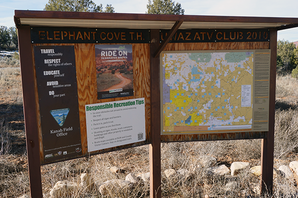
Note: There was heavy flooding through this staging area in September 2018. A new cement crossing has been finished. The staging area has recently been graveled and graded. The is a large site and handles larger RV’s, excellent views. New pit toilet installed and a map kiosk is next to the site. Camping is free.
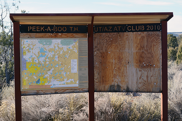
Excellent dry camp in Johnson Canyon. (Johnson Canyon, east of Kanab) access to John R flat, Crocodile, Brown Canyon and Peek A Boo, Trails, Island in the Sky (Mansard Rock Art) and Hog Canyon Trails to the west. Nearby the Nephi Pasture Staging area, a mile up the Johnson Canyon road giving access to the GSENM Nephi Pasture Trails, the Great Western Trail, Inch Worm Arch, Seaman Canyon, Fin Little Canyon, Park Wash Trail to the Buckskin, and Nipple Ranch road, the Sand Trail to Deer Springs and more.
Camping: The ATV Club has located 2 picnic tables at this site and a new vault toilet was installed in November 2017. This is a popular dry camping area with picnic tables and pit toilet. Access to Kanab is by vehicle. Pack it out, leave no trace.
Directions: Eastbound from Kanab on US Highway 89 from town 9.2 miles, look for the Johnson Canyon Scenic Byway signs, turn left (north) continue at 5.4 miles you will pass the Old Gunsmoke Movie site on the right, then at 7.8 miles you will find the Crocodile/Hog Canyon staging area on the left, GPS: 37.07884, -112.53768.
Another popular dry camp with lots of room and lots of trails to access.
5. Nephi Pasture Staging area:“Shamans OHV Trails” Posted no camping by the GSENM. The ATV Club helped in constructing this site, a pit toilet was insatlled, however, afterward the local managers at that leved decided to close it to camping and posted it. This makes no sense, because it stands empty most of the time. It is used for staging for rides from this location.
(Johnson Canyon, east of Kanab) access to Nephi Pasture trails, Seaman Wash, the Great Western trail, Deer Springs Ranch, Fin Little and Kitchen Wash, Sand Trail, Nipple Road, No Mans Mesa, Park Wash, North Swag.
Directions: Eastbound from Kanab on US Highway Highway 89, rom Kanab 9.2 miles, look for the Johnson Canyon Scenic drive signs, turn left (north) continue at 5.4 miles you will pass the Old Gunsmoke Movie site on the right at 7.8 miles you will find the Crocodile / Hog Canyon staging area on the left, at 9.3 miles you will find the Nephi Pasture Staging area on the right. GPS: N37 09.952′ W112 23.210′.
The Grand Staircase/Escalante National Monument Kanab Field Office closed this to camping. It is posted, and often sits empty.
6. Great Western Trail Staging, two areas: “Grandview OHV Trails (US Highway 89, east of Kanab) there is a north Staging area: with access to northbound Great Western Trail, Seaman Wash, Nephi Pasture, Deer Springs, Dixie NF East Fork, Paunsaugunt Plateau. Then there is the south Staging area: with access to Great Western Trail south, to Buckskin Mountain, North Kaibab NF trails and the Kiabab National Forest, Jacobs Lake and Grand Canyon. (Please note that in 2020 there was a large fire on Buckskin Mtn. and the Kiabab NF which burned many of the southern trails).
Directions: Eastbound from Kanab on US Highway 89, at 15.2 miles is the Seaman Wash Road to the left. At 16.1 miles is the Buckskin Mtn. road to the right. At 18.4 miles, another access road to the right to the GWT and points on Buckskin Mtn. At 20.6 miles (at the top of the hill) the north and south entrances to the Great Western trail staging areas. (This is where the Great Western Trail crosses US Highway 89). Turn right to the southern staging area just off the highway go across the cattle guard; GPS: N37 04.293′ W112 10.318′. Turning to the left (north) go .4 miles to the north staging area; GPS: N37 04.553′ W112 10.819′.
Both staging areas are small. Caution, roads here can become extremely muddy after rain
7. Barracks Staging area: “River Run OHV Trails” (Just west of Mt Carmel Jct.) access to the Barracks ‘River Run trail’ OHV trail along and through the East Fork of the Virgin River and a difficult sandhill climb to the Elephant Cove trails, Harris Mountain trails. Use caution riding within the Barracks takes you to the East Fork of the Virgin River. There are more than 27 crossings needed until you reach the Elephant Butte climb out trail. Be aware of the water flow of the East Fork, depending on conditions it may become impassable. Be aware of weather conditions and depth of the stream. Remember to use caution crossing the stream and the high banks. At the end of the ‘River Run’ is the difficult sandy hill to go up.

Directions: US highway 89 north from Kanab, trailer OHV’s over the sand hills. At 16.7 miles, at the base of the grade, turn left at the dirt road just before Mt Carmel Jct.. Continue west on this improved dirt road for 1.5 miles to the corrals on the left and staging area to the right. GPS: N37 12.535′ W112 41.192′
8. Hancock Road Staging area: “Hell Dive OHV Trails” Lamb Point / Indian Canyon
Access to trails to Lamb Point, Upper Water Canyon, Hell Dive, Indian Canyon and other trailheads. No kiosk here, however, camping is available. There are current plans in the works to improve this staging area.
Directions: North on US 89 to the Hancock road sign turnoff to Coral Pink Sand Dunes turn left at 7.8 miles. Follow the rough paved road 5.7 miles until you see the stop sign on the left. GPS: N37 05.892′ W112 38.699′
9. Clay Flat Staging area: “The Sands OHV Trails” Rides to Harris Mountain. (Off the Yellowjacket road. Access to riding trails to Harris Mountain, sand trails around Red Knoll, Monument knoll, and the Barracks drop off. Clay flat is a seasonable lake bed and subject to being very muddy during rainy or snowmelt conditions.
Directions: From Kanab northbound on US Highway 89 to the second sign to the Coral Pink Sand Dunes State Park, (Yellowjacket Road). Turn left onto the Yellowjacket road continue about 2 miles to the BLM Sign to the Clay Flat kiosk. GPS: N37 09.734’ W112 40.191’
10. Poverty Staging area/riding the Poverty trail: “Below Zion OHV Trails”
(East Fork of the Virgin River) Off Utah SR 9, East Zion. Riding access to the Poverty dugway, and sand trails, BLM OHV routes: BLM #70. This ride is rated ‘Most Difficult” subject to wash outs and flooding. Use caution.
Directions: From Kanab, trailer OHV’s northbound on US Highway 89 17.4 miles to Mt. Carmel Jct. Turn left onto Utah SR 9, towards Zion NP. Drive for 9.4 miles, just past milepost 48 look for a left turn onto a dirt road across a cattle guard. This is just past the Zion Mountain Ranch and resort. Turn on the dirt road, use caution as you climb the grade. (Do not go on this road if muddy). The road can be rough and be aware you are going through private property. Stay to the left (along the fence line go .5 mile (1/2 Mile) until you see parking areas on the right. You will reach a BLM map kiosk which is the staging parking area. Altitude: 6105’. GPS: N37 14.159’ W112 48.836’
************************************
Some questions raised by new members reference OHV licensing, permits and riding rules.
OHV trails you can access from Kanab: You can reach OHV Trails to the east from Kanab. (Via unmarked OHV two-track alongside of US highway 89) Look for more details below.
Access to the Eight Mile gap road, Johnson Canyon, Shinarump Cliffs, Seaman Wash, Honeymoon Trail and Great Western Trail.
From the old highway access road next to Crosby’s Hardware store, turn east on Chinle following the old, paved highway for about 5 miles. You will have access to many various OHV trails to explore. Such as the 8-mile gap road. Staying along Highway 89 access by OHV to Johnson Canyon, Seaman wash and the Great western Trail. See below for details. Remember close all gates after opening them.
Regarding OHV, ATV or UTV licensing, or permits.
Many members residing in either Utah or Arizona chooses to license street legal, otherwise you must purchase an OHV permit sticker. The reason many OHV owners choose to go street legal is because there are many trails over public lands where the government managers designate licensed vehicles only on their travel management plans. Many of these routes are dirt roads that are often used in our rides.
There is no reciprocal agreement between OHV’s between Utah and Arizona. Utah titled OHV’s must either be registered street legal or bear a Utah State permit to ride in Utah. It is the same for Arizona residents. All OHV’s are either licensed or have your states’ required OHV permit. OHV’s from all other states including Arizona must have a Utah OHV permit to ride in Utah.
Utah non-resident OHV riding ATV’s UTV’s require a $30 OHV permit. Link: https://stateparks.utah.gov/activities/off-highway-vehicles/non-resident-ohv-permits/
Arizona non-resident OHV riding ATV’s or UTV’s require a $30 OHV decal: Link: https://azstateparks.com/ohv-laws-regulations
You can ride your either licensed or Utah permitted OHV’s within the City of Kanab on designated routes, even if not registered street legal. Look for the Anasazi Trails Logo on directional signs throughout the town.
Navigating through Kanab City on OHV designated routes or finding designated routes by OHV:
From Kanab for OHV Northbound Travel: To Hog Canyon Trails.
Starting point is US 89 Eastbound, at the Subway Sandwich Shop at 300 East. Follow the signs as best as possible, West on 300 E to 300 S to 300 W turn left and go .9 miles to US 89 Northbound. Turn right and follow ATV trail as described Below. NOTE: there are other OHV routes through the City as marked by signs, however, to go north from the RV Parks starting at Subway will get you to Hog Canyon Trails. Remember stay on the pavement and to the right keep the noise and speed to the minimum.
For Eastbound OHV Travel: To Johnson Canyon Trails, Eight Mile Gap Road, Seaman Wash Road:
Starting point, US 89, at the Subway Sandwich Shop, go East on the side of US 89 to 700 East (across from Wendy’s) at Crosby’s Farm Store, turn right a short distance to Chinle Dr. (the old US 89 road) turn left east and follow this road 4.7 miles where you can turn left to access US 89. (If continuing straight on you will go onto the Eight Mile Gap Road as you turn to the South and the pavement ends).
To continuing east along the side of US 89 you find a two track along the South side of the highway. You will have to ride along the side of the highway (not signed) behind the Cowboy Storage yead at highway 89 following the two track for 3.6 miles to the Johnson Canyon Road or continue another 2.8 miles along the side of the highway up the hill (this is a rough track) to the first right turn go south to another intersection road, turn left (do not go through a ranch access gate directly to the south) follow the gravel road East 3.1 miles to an intersection, (Honeymoon Trail Monument) turn left for Seaman Wash (Monument Road 705) go .3 miles cross US 89 to enter the Seaman Wash Road. Continuing East past the Honeymoon Trail monument the road dead ends. Turning right will take you to Buckskin Mountain and the Great Western Trail. See maps for details…
One final offer from the Utah/Arizona ATV Club. Feel free to come and ride with our club at any of our club Saturday rides, campouts or multiday rides. All information can be found on our website or Facebook page. Have fun and be careful in Kane County.
Remember the rules of OHV safety: use protective gear and wear your helmet, bring survival gear, and lots of water, repair kits, maps, never ride alone and tell someone where you are going. When riding in sand lower your tire pressure and drive in 4×4 to prevent trail damage.
Always stay on designated routes and TREAD Lightly.
Remember the rules of OHV safety: use protective gear and wear your helmet, bring survival gear, and lots of water, repair kits, maps, never ride alone and tell someone where you are going.
Always stay on designated routes and TREAD Lightly.
(Please note that the roads can become extremely muddy in rainy or snow melt conditions).
MotoCaching: is simply GeoCaching using OHV’s to find the caches. Most of these Geocaching locations are reached ffom these Staging areas. All of the caches are near the trails or roads and do not require strenuous climbing or rough walking. Most caches are placed near points of interest or great views; so bring your camera. The caches are also listed on Geocache.com. Have fun finding them and exploring our special place in the world. Be Safe. (Please note that these sites have not been kept current).
Utah/Arizona ATV Club Motocache locations: Thanks to Don and Karen Kramer.
Locations by name:
Eye on Fredonia: N 37 03.731 W 112 26.519
Cowboys Cave Glyphs: N 37 09.282 W 112. 25.974 (From Peek A – Boo)
Stout Overlook: N 37 29.960 W 34 756 (From Clay Flat)
Dino TopPia: N 37 00.155 W 112 48.755 (From Elephant Butte)
Brown Canyon Cabin: N 37 11.340 W 112 28.653 (From Peek A – Boo)
Three Bears: N 37 13.081 W 112 33.382 (From Peek A – Boo)
Sheep Wagon: N 37 12.257 W 112 28.600 (From Peek A – Boo)
Red Pinnacles: N 37 10.265 W 112 27.792 (From Peek A – Boo)
Peek A Boo: N 37 10.773 W 112 33,534 (From Peek A – Boo)